Garmin
190 商品


| 一般評価 | (70 評価) |
Rugged, Full-featured Handheld with GPS, GLONASS and Wireless Connectivity
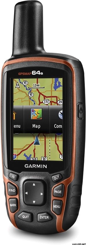
2.6" sunlight-readable color screen
High-sensitivity GPS and GLONASS receiver with quad helix antenna
1-year BirdsEye Satellite Imagery subscription
3-axis compass with barometric altimeter
Wireless connectivity via Bluetooth® technology¹ or ANT+™
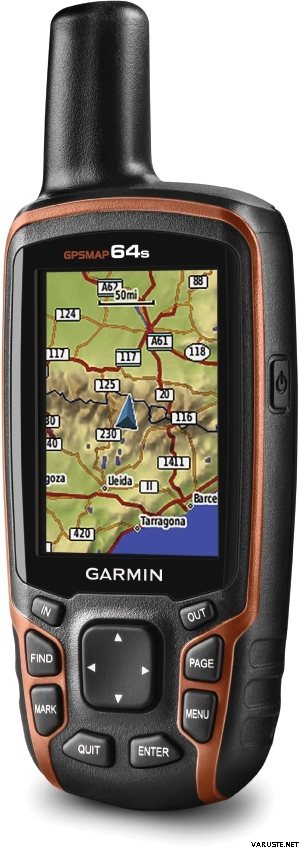
GPSMAP 64s
GPSMAP 64s features a 2.6” sunlight-readable color screen and a high-sensitivity GPS and GLONASS receiver with a quad helix antenna for superior reception. GPSMAP 64s includes a 3-axis electronic compass with barometric altimeter, wireless connectivity and a 1-year BirdsEye Satellite Imagery subscription.
Get Your Bearings
GPSMAP 64s has a built-in 3-axis tilt-compensated electronic compass, which shows your heading even when you’re standing still, without holding it level. Its barometric altimeter tracks changes in pressure to pinpoint your precise altitude, and you can even use it to plot barometric pressure over time, which can help you keep an eye on changing weather conditions.
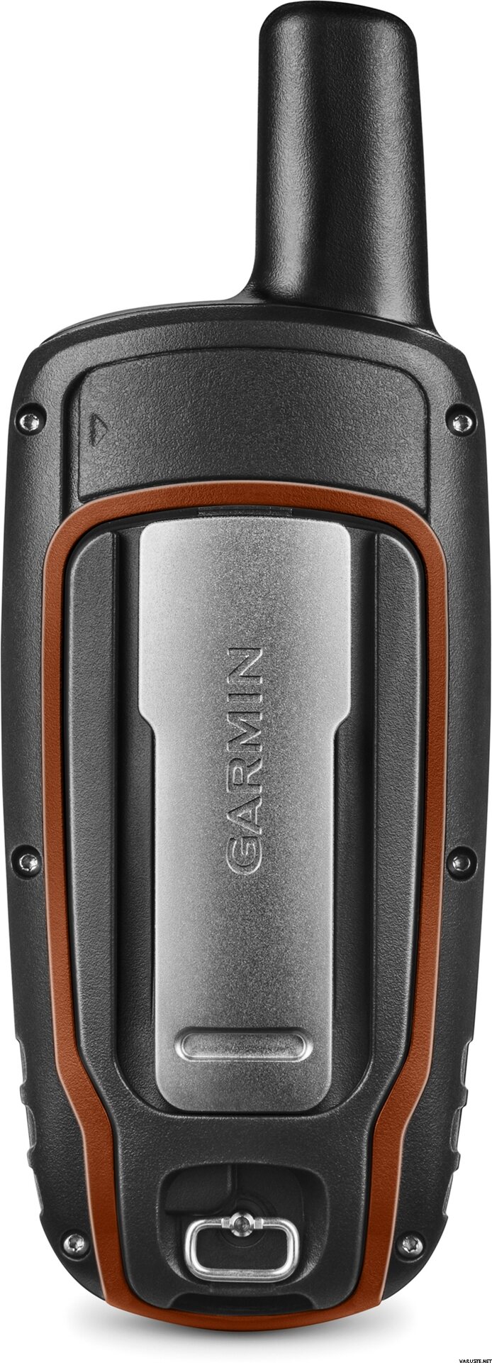
Share Wirelessly
Share your waypoints, tracks, routes and geocaches wirelessly with other compatible devices. Your friends can enjoy your favorite hike or cache without waiting for you to plug in to your computer — simply press “send” to transfer your information to another Garmin handheld.
GPSMAP 64st also connects to compatible Garmin devices, including VIRB™ and accessory sensors, including tempe™, foot pod and heart rate monitor.
Stay Connected
With Smart Notification you can wirelessly receive email, texts and alerts from your compatible iPhone® 4s or later. Stay connected without having to dig into your backpack for your smartphone.
Explore the Terrain
GPSMAP 64s comes with a built-in worldwide basemap with shaded relief plus a 1-year BirdsEye Satellite Imagery subscription, so you can navigate anywhere with ease. With photo navigation, you can download geotagged pictures from the Internet and navigate to them.
Keep Your Fix
With its quad helix antenna and high-sensitivity, GPS and GLONASS, receiver, GPSMAP 64s locates your position quickly and precisely and maintains its location even in heavy cover and deep canyons. The advantage is clear — whether you’re in deep woods or just near tall buildings and trees, you can count on GPSMAP 64s to help you find your way when you need it the most.
Add Maps
GPSMAP 64s comes with a built-in worldwide basemap with shaded relief and a 1-year subscription of BirdsEye Satellite Imagery for a photo-realistic view. Adding more maps is easy with our array of detailed topographic, marine and road maps. With 4 GB of onboard memory and microSD™ card slot, you can conveniently download TOPO 24K and 100K maps and hit the trail, plug in BlueChart® g2 preloaded cards for a great day on the water or City Navigator NT® map data for turn-by-turn routing on roads (see maps tab for compatibility). In addition, the 64s is compatible with Garmin Custom Maps, a map format that allows you to transform paper and electronic maps easily into downloadable maps for your device, for free.
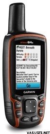
Find Fun
GPSMAP 64s supports paperless geocaching with 250,000 preloaded caches with hints and descriptions from Geocaching.com, and has a 16-hour battery life. By going paperless, you're not only helping the environment, but also improving efficiency. GPSMAP 64s stores and displays key information, including location, terrain, difficulty, hints and descriptions, which means there’s no more manually entering coordinates and paper printouts! Slim and lightweight, 64s is the perfect companion for all your outdoor pursuits.
Plan Your Next Trip
Take charge of your next adventure with BaseCamp™, software that lets you view and organize maps, waypoints, routes and tracks. This free trip-planning software even allows you to create Garmin Adventures that you can share with friends, family or fellow explorers. BaseCamp displays topographic map data in 2-D or 3-D on your computer screen, including contour lines and elevation profiles. It also can transfer an unlimited amount of satellite images to your device when paired with a BirdsEye Satellite Imagery subscription.
 台湾
台湾| 一般評価 | ☆☆☆☆☆ |
 — オリジナルを見る
 — オリジナルを見る
最初のgpsデバイスの場合、初心者が必要とする指示を正確にマニュアルで見つけることは困難でした。パッケージにはフィンランド語の説明がまったくなく、オンラインで見つけるにはインターネット接続と、若い人たちの助けがなければ70歳以上のベリーが少ないスキルが必要です。つまり、フォレストにはデバイスを使用するためのアシスタントが必要です。| 一般評価 |
— オリジナルを見るこれは、救助犬の任務のための姉妹への贈り物として来ました。伝えられるところによると良かったです。 Vehjeは私たちの共同Hammastunturiハイキングにも関わっており、そこではどこでも機能することがわかりました。交差点で場所が約100メートル間違っているように見えることに一度だけ気づきましたが、それ以外の場合は常に正確に見えるように見えました。 — オリジナルを見る比較的使いやすく、充電が速く、走行距離が数百メートルしかない場合でも、トリップコンピューターに奇妙な走行距離が表示されることがあります| 一般評価 |
— オリジナルを見る優れた基本的な安全装置。
ナビゲーションデバイスとしてウォータージェットを購入したので、互換性のあるウォーターマップとスタンドにさらに+150ユーロを投資する必要がありました。
正常に動作し、信号が不必要に中断されることはありません。防水。
単三電池またはニッケル水素電池で使用でき、画面の明るさがいっぱいの場合でも、1回の充電で1日中軽く持続します。
お金に良い値。| 一般評価 |
— オリジナルを見る使用説明書もフィンランド語である必要があります。用途が広く、信頼性があります。 — オリジナルを見る現時点ではまだあまり使用されていませんが、かなり良いパッケージです| 一般評価 |
— オリジナルを見る屋外で使用する場合、1日中持続するバッテリーを備えた唯一のデバイス。手袋をしたままでも着用できます。含まれているマップでは、画面の更新が遅くなります。メニューシステムは以前のモデルよりも優れていました。| 一般評価 |
— オリジナルを見るうまくいきましたが、まだあまり地形がありません。| 一般評価 |
— オリジナルを見るジオキャッシングに便利な正確な石膏。デバイスにはキーボタンがあるため、夏と冬の霜で動作します。
無駄に、それらのプリロードされた伝統があります、あなたがそれらの不必要なフォルダーを削除するとき、そしてそれらはそのような素晴らしいゲームのためにgpxファイルと地形マップをダウンロードします。